This site intends to provide the most extensive and most easily accessed directory for realestate services and information in the southern Gulf Islands BC area. We also provide detailed information on the islands and area. This site is new (February 2002).
If you are looking for links to Realtors, developments, appraisers and other professional services or for more area information, tourism information, and recreation guides check our directory of annotated links.
If you offer real estate related services or host a site please submit your links to the appropriate category in the directory. We appreciate a link back to this site, and you will find that such reciprocal linking is beneficial to all.
The Gulf Islands, situated off the east coast of southern Vancouver Island (see map, below), are normally divided into northern and southern sections, the southern group consists of 11 major islands ( North to South: Gabriola, Valdes, Thetis, Kuper, Galiano, Saltspring (Salt Spring), Prevost, Mayne, North and South Pender and Saturna) plus several smaller islands. The southern Gulf Islands and the San Juan Islands to the south are part of the same archipelago, despite the national boundary. The Saanich peninsula also shares some of the same characteristics, although heavily modified by agriculture and urban development.
The San Juan Islands are located just to the south of the southern Gulf Islands in the northern reaches of Puget Sound. There are five main islands in the group; San Juan Island which is the Saltspring of the San Juans and has an area of 55.3 square miles and population of 7000, Lopez with an area of 29.5 square miles and population of 2100, Orcas with an area of 56.9 square miles and population of 4500 and Shaw Island which is most similar to Thetis and has no amenities but is served by ferry. Shaw has an area of 7.7 square miles. Population is 231. As with the Gulf Islands there are numerous small islands, the largest being Blakely Island.
The Gulf and San Juan islands have been seasonally occupied by central coast Salish tribes from approximately 5000 years ago through the eighteenth century. According to tradition, the Songhees, Saanich, Lummi, and Samish all had winter villages in the southern Gulf and San Juan islands, as well as many permanent structures for other seasons.
The Haida and other tribes raided these tribes for slaves on a regular basis, which may account for Thetis Island having no native population at the time Europeans first arrived.
The seasonal and local availability of fishery resources had a great impact on population movements and settlement patterns of local Indian tribes. During summer months, populations commonly disbanded and dispersed to locations where resources were seasonally available. Small units of people left their winter villages and migrated to optimal fishing and plant gathering areas, where they resided in temporary lodges. It is thought that Native Americans encouraged native grasslands and oak woodlands through the use of fire, in addition to natural fires and wildlife pressure.
Vancouver Island was first surveyed by Captain Cook, but there is some contention that Francis Drake actually explored the British Columbia coast in 1579 and sailed through the Straight of Georgia.
The main settlement of the islands by Europeans began in the 1870's. Early settlers also included escaped slaves from the US.
All the islands are known for their peaceful, rural character, despite their proximity to the major urban centers on Vancouver Island as well as the cities of Vancouver, Tacoma and Seattle. These centers, located within a radius of 100 miles, have a combined population of over four million.
The Gulf Islands are administered by various regional districts (Cowichan Valley Regional District-CVRD for Thetis Island), and also fall under the Islands Trust, which is intended to preserve and protect the islands. The San Juans fall under the administration of San Juan County.
We will be expanding this section of our site to include detailed information on individual islands, and further maps. If you have information to add, please let us know.
There are several good online guides to the Gulf and San Juan Islands, see our "Links" pages for details. Here is an outline of the characteristics of the main southern gulf islands. Population estimates are of full time residents.
The smallest, least populated of the islands served by a vehicle ferry. Follow the link for further details.
Thetis Island is about 1035 Ha (2560 acres) in area, and home to a small community of about 340 people (with summer residents in addition). The island lies about 5 miles off Chemainus on Vancouver Island and is about 35 miles west of Vancouver. Local facilities include a kindergarten to grade seven school, community center, pub and restaurant, Post Office and small store, a garden nursery, two marinas and a well-equipped volunteer fire department with paramedic support. There are no parks, but there are public access points to the oceanfront.
Public access to the shoreline and beaches is good and the west side of the island offers an attractive walk at mid to low tide, plus beautiful sunsets over vancouver island.
Check out Meadow Valley Properties real estate on Thetis Island, an unique environmentally planned strata development.
Just east of Nanaimo, Gabriola is about 14 km long and 4 km wide. With a Population of about 3000, with many commuters, it is quite developed. Has three provincial waterfront parks and is well known for its interesting shoreline sandstone formations..
Saltspring island is the largest and most developed of the Gulf Islands. This leads to the lifestyle being more like that on the lower mainland or the Saanich peninsula than on an island like Thetis. Salt spring island is about 27 km long and 13 km wide, about 180 sq. km. With a Population of 11,000. The main town of Ganges is located centrally and is quite developed, with all services and an interesting Saturday market. The south end of the island includes the agricultural valley of Fulford, the village of Fulford Harbor and the hilly/mountainous MT Tuam/Musgrave area in the southwest, which is sparsely developed. The north end of the island is fairly densely developed and has the village of Fernwood. Named after the salt springs found on the northern part of the island.
Galiano is long and thin, about 25 km long and mostly about 2 km wide (with a larger landmass at the southern end), about 57 sq. km. With a Population of about 1,000. Off the northern end is Porlier Pass (visible from Thetis) and Valdes Island, a large but relatively uninhabited island not served by ferry and mainly owned by a forestry company. Named after Dionisio Galiano the commander of a Spanish schooner, exploring the area in 1792.
Separated from Galiano by Active Pass (where the Tswassen - Swartz Bay ferries go between the islands) Mayne is about 7 km long by about 4 km wide, about 21 sq. km. With a Population of 900. Mayne was settled early, with the earliest homesteaders registering land claims in the Miners Bay area in 1859.
Saturna is the southwesternmost of the Gulf Islands. About 8 km long by 4 km wide, 31 sq. km. With a Population of 350. It consists of two lines of hills trending east west with a valley between, somewhat like a larger version of Thetis. Saturna also shares with Thetis many of the relatively undiscovered tranquil rural attributes that we value, however, getting there by ferry can take a few hours. Notable for the recently developed Saturna Island vineyards and the annual Canada day lamb barbecue. Named after a Spanish schooner, the Saturnina.
As with Thetis and Kuper, a dredged channel separates these islands. Unlike Thetis and Kuper, they are joined by a bridge. The area of the two islands combined is about 34 sqkm. With a Population of about 2,000. The northern island is quite densely developed.
The Islands Trust
Planning and land use regulation on the Gulf Islands is the responsibility of the Islands Trust, a body established by the provincial government to "preserve and protect" the unique environment of the Gulf Islands for their residents and for the people of B.C..
Up to Top.
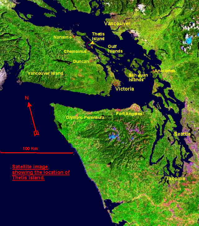
Map of southern Gulf Islands, San Juan Islands, Southern Vancouver Island and
area, showing location of Thetis Island. (Please scroll down and read on if
this map hasn't loaded yet).
Up to Top.
When you submit a link to our link directory please place a reciprocal text link on your site to us. Reciprocal links serve to improve both the value of our sites and our visitor's experience. They also improve your search engine ranking.
Add a link from the appropriate category (follow directions), we will review the link before activating it.
For further information contact Trax Developments
This is not intended to be exhaustive directory, although we have included links to the best quality sites that we are aware of for each area of interest. Note that sites may change their content (or disappear)without us knowing. We do not guarantee the accuracy of information on these sites, nor do we necessarily endorse their positions on issues. Let us know if we are missing something!
This site is not intended to make a profit at any time, and its purpose is to promote the southern Gulf Islands and Thetis Island real estate whilst providing a useful public service and enriching the web community.
We have made this site as accessible as possible, it does, however, use cookies when you are submitting a link. These session cookies are only used while you are at the site and do not stay on your computer, they do not collect information about you. Please let us know if there are improvements we can make to the site experience.
Site designed and maintained by Trax
Developments Ltd. website design and Internet programming
Box 9-6, Thetis Island BC, V0R 2Y0. Canada 250-246-4774